Murrumbidgee – Jugiong to Gundagai

I have always loved the Murrumbidgee River. In 2013 I spent 3 days paddling down the Murrumbidgee from Gundagai to Wagga Wagga (see previous post) and since then I have been wanting do that trip again solo. Not only that, I have also wanted to do some more of the river both upstream from Gundagai and downstream from Wagga Wagga.
This week I am on a week of holidays, so I thought I would start my progressive journey down the Murrumbidgee. At the end of next week, I will be finishing work and taking some time off (more about that in a later post), so I plan to do further trips down the river.
So for this first trip, the plan was to travel from the town of Jugiong and head down past Gundagai on a 3.5 day paddle.
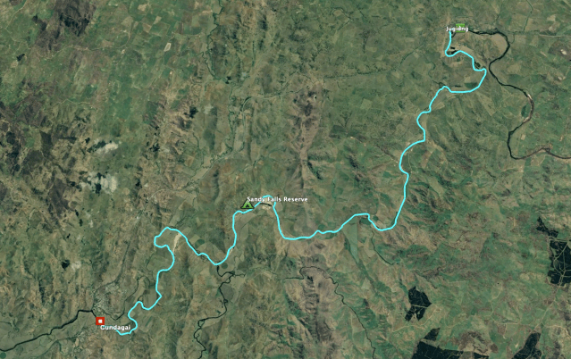
Day 1 – Jugiong to Sandy Falls Reserve
I have to say that was one of the hardest days of paddling I have ever done. The Murrumbidgee below Burrinjuck Dam is really low at the moment because they don’t let much water at this time of the year. Not only is it hard because you have to spend a lot of time getting out of the boat and walking down the river (literally in the river) to save the boat from dragging on the bottom of the river bed, but also because when the water is shallow you get a lot of resistance from the wave under the boat bouncing off the river bed.


This leg was about 41 km and in all it took me about 9 hours in the end. My Mum, Dad and uncle (who all live about 30 minutes away from Jugiong) dropped me off at the Jugiong Showgrounds. Being that the river is so low, there was only one track you could use to get down to the river, which was nestled amongst the many caravans set up in the Showgrounds. I think every grey nomad in Australia had decided to pack their caravans and headed to Jugiong to avoid the Covid-19 pandemic.
After packing the boat with way too much gear, and a lovely farewell from the family, I started my journey. It was after just the second bend in the river that I was lucky to see my first platypus swimming around an old log. It was about 20 minutes later, when the river started getting shallower and shallower. However, it wasn’t until about an hour down the river when I had to get out of the boat to walk down my first pebbly rapid to save the bottom of the boat. Soon this became a more frequent occurrence, and at one point I had to wade (up to my waste) through a messy rapid that was covered in fallen trees. Many of these I could have probably negotiated in a white water kayak, but in my heavy laden sea kayak, which is nearly twice as long as a white water boat, it was not worth risking.
You know the water is really low when you can identify the really shallow sandbars by the trout swimming with half their bodies out of the water.
Despite all the frustration of scraping the bottom of my boat on the river rocks and getting stranded on sand bars, it was a very pleasant first day. There are an incredible number of birds on the river at this time of the year. Lots of pelicans, swans, ducks, sea eagles and a huge number of cockatoos.
The river winds its way through the farming areas around Jugiong and Coolac. There are plenty of cows and sheep along the banks who give you very curious looks as you float by. At one point I came across a feral sheep with a long coat and a long bushy tail. It was obviously lonely because she followed me down the river for a way, calling out to me.
After a long day of paddling and the beginnings of a sore wrist, I made it to my campsite at Sandy Falls Reserve at around 5pm. The reserve is a large sandy beach (especially at this time of the year), that is available for free camping. It is a nice quiet spot with plenty of birds flying around. There were a couple of bulls in the paddock on the other side of the river that decided to make a lot of noise just after I got into bed, but I was so exhausted that I quickly fell asleep.
Day 2 – Sandy Falls Reserve to Gundagai
I woke to a lovely sunrise and a very clear day. It seemed that the river had risen a small amount overnight. The fact that the water was a little higher and very brown, would suggest they had released some water over night. After multiple trips across the 100 metres of sand from the campsite to the river, I got all my gear in the boat and hit the water at around 9am. I had only 26 kilometres to cover and since the water seemed to be flowing faster, it didn’t look like it was going to be a hard day. I was just hoping the water would be deeper and I could stay in my boat more.


The river proved to be much deeper all day especially after I passed the junction of the Tumut River. I only had to get out of my boat once to get off a sandbar. The paddle was pretty uneventful compared to the day before and it was nice just to take my time, just drifting at times, to take in the scenery and watch the crazy number of birds flying around.
At about 2pm I rounded the final bend and saw the two bridges of Gundagai. My destination was the Gundagai River Camping & Caravan Park, which lies on the river between the two bridges. They provided me with a lovely campsite under a huge shady tree, which was ideal to spend the afternoon on the laptop playing around with my hundreds of photos and videos.


Later that afternoon I ventured into town and was able to enjoy a couple of quiet Sunday afternoon beers at the Family Hotel and a Chinese dinner at the local takeaway.
Day 3 – Gundagai to Home
The plan had to paddle another day down the river to Limekilns Reserve (the first leg of the trip I did in 2013), however when I woke up my wrist was swollen. I decided that it wasn’t worth risking my future trips for the sake of doing another day. Plus in a couple of weeks I had planned to do the Gundagai to Limekilns leg again, so I wasn’t really going to miss out on anything. So I messaged my folks, who came down from Binalong with my car and after a quick breakfast in Gundagai, I headed back to Sydney.

It was a great couple of days. It was so good to just get away from all the stress and uncertainty that is going on in the world at the moment. Sometimes going back to basics and appreciating nature is the best way to deal with the hard times. What is even better is that I can go and do it again in less than 2 weeks.
Details:
Trip Distance: 65.2km
Water Level: 1.87m (Low)
Water Level details: http://www.waterwaysguide.org.au/map?nid=6339

Pingback: Murrumbidgee River – Gundagai to Wagga Wagga | Robbo - The Blog of Andrew Robertson