
Sydney – Top 5 Paddles

Below are all the details about my Top 5 Paddles in Sydney, as featured in the video above.
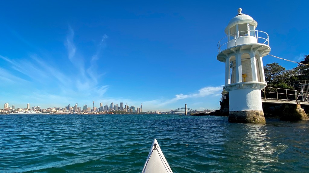
#1 – Sydney Harbour
Description
This is an iconic paddle and had to be the No.1 paddle on my list. This has been one of my most regular paddling areas because there are so many different directions you can explore. I tend to launch at Clontarf Reserve (where there is free parking) and head out towards Grotto Point. Once at Grotto Point you can either head towards Manly (to the North), head out to the Sydney Heads (to the East) or head towards the city (to the South).
Being that this is Sydney Harbour, there are plenty of things to see and always a lot of action on the water. If you head to the city you can paddle right up to many of Sydney’s iconic locations, including Bradleys Head, Taronga Zoo and the Sydney Harbour Bridge.

Launching Point
I like to launch at Clontarf Reserve because it is easy to access and there is free parking if you park on Monash Crescent. If you go into the main Clontarf Reserve carpark (in the picnic area) you will have to pay for parking. You can park at The Spit near Sydney Harbour Kayaks, but it is expensive and it is a nightmare to navigate getting to the parking and out of it because of a lot of “No Right Turn” and “No Left Turn” signs.
Google Map: https://goo.gl/maps/MYWP6gtqCT6cXRkHA

Options, Distances and Points of Interest
There is plenty of things to explore and check out. Below is a list of things to look check out (broken into the 3 different directions you can head.
Clontarf Reserve to Sydney City – 10km one way
- Middle Head
- Chowder Bay
- Bradleys Head (and HMAS Sydney)
- Taronga Zoo
- The Lodge (The PM’s house)
- Sydney Harbour Bridge
- Luna Park
- The Opera House (if you want to cross the harbour with all the ferry traffic)
Clontarf Reserve to Manly Beach – 9.5km one way
- Dobroyd Head
- Reef Bay
- Manly Cove Beach
- Manly Warf
Clontarf Reserve to Shelly Beach – 9km one way
- The Quarantine Station
- North Head
- Shelly Beach
- Manly Beach
Things to Watch Out For
- Manly ferries and Manly Fast ferries go by about every 15 minutes. They stick to the middle of the harbour, so should not cause too many issues. If you are heading out to the main heads, you will need to time your crossing of the harbour.
- Middle Head and around the Sydney Harbour Bridge can get very choppy
Good Eating after the Paddle
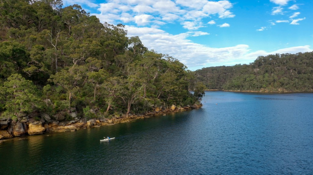
#2 – Cowan Creek (Bobbin Head)
Description
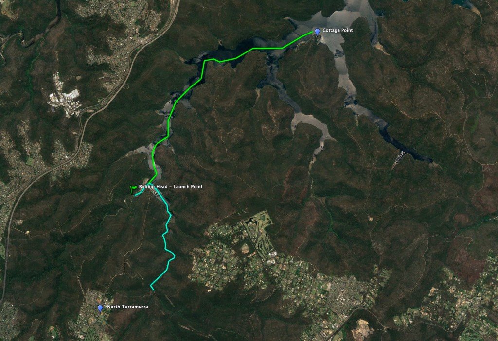
This is the location that I paddle the most regularly as it is very close to my home. This close proximity is not the reason that it rates so highly, it is because it is such a beautiful and peaceful spot. The paddle starts from the Bobbin Head Picnic Grounds and you can either head the South (turning right) and go up Cowan Creek, past the marina or you can head North (turning left) and head to Cottage Point. Both directions are excellent paddles and allow you to really enjoy the surrounding Ku-ring-gai Chase National Park.
One word of warning, if it is low tide, heading up Cowan Creek can get quite shallow in parts. I tend to avoid going that way in low tide.
Launching Point
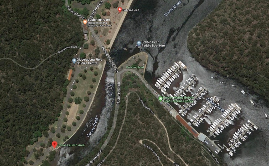
The Bobbin Head Picnic Area can be accessed from 2 directions. You can come from the South via North Turramurra or you can come from the North/West via Asquith. There is a designated Canoe Launching Point at the Southern end of the Bobbin Head Picnic Area. If it is low tide, Cockle Creek (where you get in) is pretty shallow. The Picnic Area is in the National Park, so you will either have to pay for parking or have a National Parks annual pass.
Google Map: https://goo.gl/maps/pu7Y7RDW5U6Emscp8
Options and Distances
There are basically 2 directions that you can head and both are great paddles. If you head towards Cottage Point (to the North) you are unlimited in how far you can go.
- Bobbin Head Picnic area to Cowan Creek South – 9km return
- Bobbin Head Picnic area to Cottage Point – 7.7km one way
Things to Watch Out For
- If the tide is low, heading up Cowan Creek (to the South) can get pretty shallow
- Watch out for cyclists on the roads heading down to Bobbin Head (especially if coming from Turramurra and on weekends). It is a very popular road for riding and you may need some patience while driving behind these cyclists (especially heading up the hills).
Good Eating after the Paddle
- Bobbin Hot Bread & Cake Shop – North Turramurra
- The Cooks Garden – North Turramurra (Opens at 11.30am)
#3 – Scotland Island

Description
Scotland Island sits at the southern end of Pittwater and makes for a great paddle. If you want a relatively short trip, you can can simply paddle around the island. Otherwise you can head further up into Pittwater, past The Basin and up towards Palm Beach.

Launching Point
There is a great launching point at McCarrs Creek Reserve, which provides free parking and is an easy place to put in.
Google Map: https://goo.gl/maps/nMaZYtgcgUUP8RW19

Options and Distances
There are many options and they are all great paddles.
- McCarrs Creek Reserve around Scotland Island – 9km return
- McCarrs Creek Reserve to Palm Beach – 9km one way
Good Eating after the Paddle
#4 – Palm Beach

Description
Palm Beach sits at the northern end of Pittwater and is right next to the mouth of the Hawkesbury River. From Palm Beach you can basically head in any direction. Paddling around the Barrenjoey Headlands is always a fun paddle (if the swell is not too high) and there is a colony of seals that live amongst the rocks. You can also head further north, into Broken Bay, towards Lion Island, Patonga and Umina.
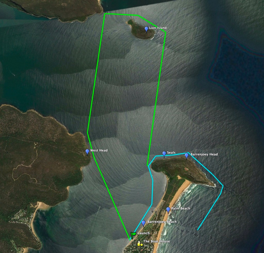
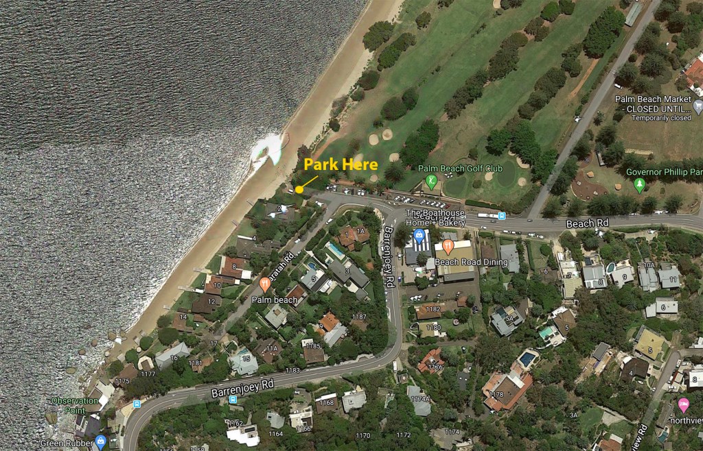
Launching Point
The temptation is to park in the various carparks at the northern end of Barrenjoey Beach… but don’t. It is pretty expensive. There is a small, free parking spot near the golf course club house at the southern end of Barrenjoey Beach.
Google Map: https://goo.gl/maps/Mudci4BzdJTBfkYB7
Options and Distances
There are a couple of trips that I regularly do.
- Around Barrenjoey Head – 8km return
- Around Lion Island – 10km return
Things to Watch Out For
- Once you go around the headland, it can get quite choppy because you are basically in the ocean.
- There is a seal colony on the headland. You can sometimes also see seals at the base of West Head.
Good Eating after the Paddle
#5 – Berowra Waters
Description
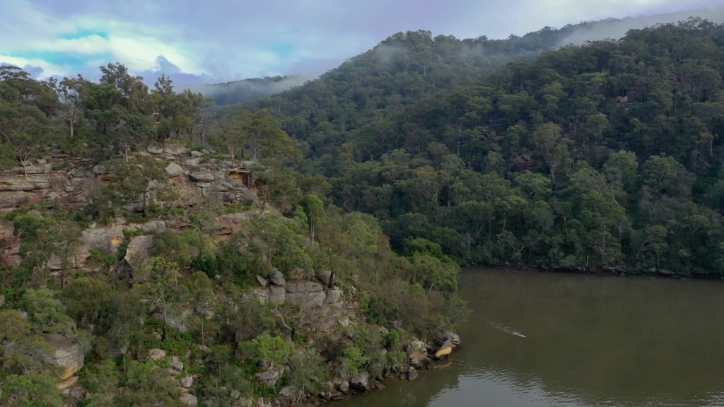
Berowra Waters is a real a hidden gem. It is a great spot if you want to escape the hustle and bustle of city life. From Berowra Waters you can head to the South towards Crosslands Reserve, however I generally prefer to head to the North (as shown in the video). There are lots of inlets to explore and it nice open waterways to paddle along. You can get some pretty spectacular fog and mist around the hills if you paddle first thing in the morning.

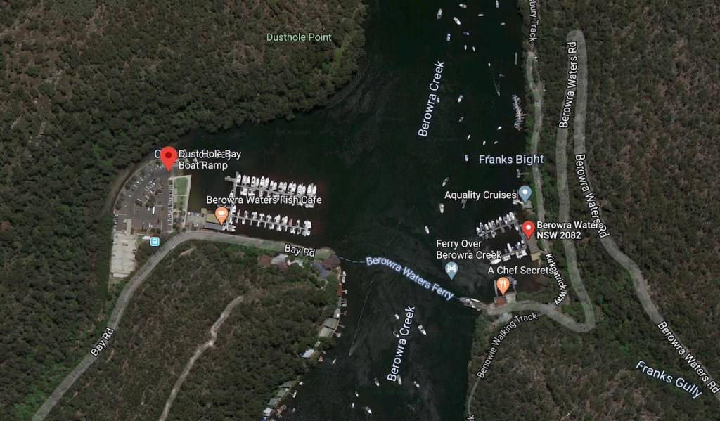
Launching Point
There is a great boat ramp (Dust Hole Boat Ramp) at Berowra marina. Parking is free and there is a great cafe (Berowra Waters Fish Cafe) right next to it. If you are coming from the East (Berowra Heights), you will need to cross Berowra Creek on the car ferry. The ferry runs 24/7 and only takes a few minutes to cross.
Google Map: https://goo.gl/maps/nMaZYtgcgUUP8RW19
Note – Ferry Closure 1 June 2020 for 6 weeks
https://www.rms.nsw.gov.au/projects/berowra-waters-ferry-upgrade/index.html
There is going to be 6 weeks of upgrade works being done to the Ferry and will be closed for 6 weeks. You will be able to access the marina from the West (via Arcadia). I have never found a launching point on the Eastern (Berowra Heights) side, but you may be able to get creative.
Options and Distances
There are basically 2 directions that you can head and both are great paddles.
- Berowra Waters to Berowra Creek Campground (via Crosslands Reserve) – 14km return
- Berowra Waters towards the Hawkesbury River – As far as you want
Things to Watch Out For
- Heading to the South towards Crosslands Reserve can get pretty shallow if it is low tide and you will find you hit the bottom of the creek a fair bit (especially past Crosslands Reserve. The tide can also be quite strong in both directions, so plan your paddle so you don’t need to paddle against it.
Good Eating after the Paddle

Hi, thanks for such a great article. Excuse my ignorance but it’s mentioned to watch the tide and plan so you’re not against the tide when paddling from Berowra to crosslands. Can you tell me when I paddle from Berowra to crosslands, to run with the tide, do I do that in high tide ot low tide.
There is a good app called Willy Weather that shows the tides. It is a great resource and I use it all the time